Feb 2025 – Apr 2025
National Consultant (digital map of the State Border Service)
Parallel engagementUNDP — Aid for Trade in Central Asia project (phase V)
Bishkek, Kyrgyz Republic
GIS & Geospatial Expert
14+ Years of Professional Experience
Transforming Geospatial Data into Intelligent Mapping and Decision-Making Solutions.
14 Years of Experience in GIS, Geospatial Analysis and Land Surveying.
14+ years
Professional experience since 2012
Government & international
State agencies of the Kyrgyz Republic; projects with the World Bank, FAO, UNDP and REC CA
GIS · Remote Sensing · Cadastre
Spatial analysis, land-use mapping, land inventory
Geodata & cartography
Geodatabases, thematic maps, basin plan maps and atlases
About
I am a Geographic Information Systems specialist with 14 years of experience in land surveying and land management, cadastre, cartography and spatial analysis. I graduated in Land Management from the Kyrgyz National Agrarian University named after K.I. Skryabin in 2012 and have worked with spatial data ever since.
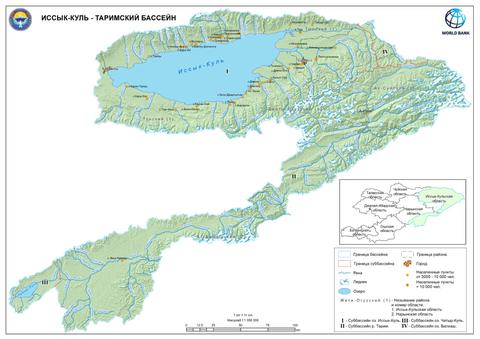
My work covers water and land resources management, the creation of GIS databases, thematic mapping, remote sensing and the development and testing of interactive GIS solutions. I have prepared maps and schemes for river basin plans, atlases of pilot river basins, a digital land-use map of Kyrgyzstan and digital cartographic materials for the national land fund inventory.
I have worked in state organizations of the Kyrgyz Republic and taken part in projects financed or implemented by the World Bank, FAO, UNDP and the Regional Environmental Centre for Central Asia.
Bars show the exact periods from the CV. Some engagements ran in parallel.
Experience
Feb 2025 – Apr 2025
Feb 2025 – Apr 2025
UNDP — Aid for Trade in Central Asia project (phase V)
Bishkek, Kyrgyz Republic
Jan 2024 – Jul 2026
Jan 2024 – Jul 2026
Ton District Branch of the State Agency for Land Resources, Cadastre, Geodesy and Cartography under the Cabinet of Ministers of the Kyrgyz Republic
Ton District, Kyrgyz Republic
Jul 2020 – Dec 2023
Jul 2020 – Dec 2023
State Water Resources Agency under the Ministry of Agriculture of the Kyrgyz Republic
Kyrgyz Republic
Apr 2020 – Oct 2020
Apr 2020 – Oct 2020
FAO / Kyrgyzgiprozem SPI
Kyrgyz Republic
Mar 2020 – Aug 2020
Mar 2020 – Aug 2020
Kyrgyz Branch of the Regional Environmental Centre for Central Asia
Kyrgyz Republic
Mar 2019 – Aug 2019
Mar 2019 – Aug 2019
FAO
Kyrgyz Republic
Sep 2018 – Aug 2019
Sep 2018 – Aug 2019
Department of Water Resources and Land Reclamation of the Kyrgyz Republic
Kyrgyz Republic
2016 – 2018
2016 – 2018
Kyrgyz National Agrarian University named after K.I. Skryabin, Agricultural College
Bishkek, Kyrgyz Republic
Aug 2012 – Mar 2018
Aug 2012 – Mar 2018
Kyrgyzgiprozem
Kyrgyz Republic
International projects
A trilingual digital map that aggregates and visualizes information on the border regime and border zone of the Kyrgyz Republic for citizens, government agencies, tourism businesses and tourists — supporting Task 11 of the Programme on Sustainable Tourism Development (2025–2030).
 2020–2023
GIS support for basin planning: detailed maps and schemes for River Basin Plans, thematic mapping, data management and quality control of GIS software.
View DetailsTechnical GIS assistance: geodatabase creation and management, digitising of land-use maps and capacity building for GIS specialists.
Thematic mapping and spatial analysis for river basin atlases.
View DetailsField inventory of arable land and land-use types under the 2006 IPCC Guidelines and a digital land-use map of Kyrgyzstan (LULUCF).
Basin maps and schemes, thematic mapping, spatial data processing and checking, and support of GIS applications.
View DetailsInventory and accounting of the land fund of the Kyrgyz Republic: UAV aerial photography, orthophoto digitising, vectorisation, georeferencing and thematic cartography.
Organization names identify past clients and projects only; they do not imply current partnership or official representation.
Education
2007–2012
Certifications
7 certificates
Skills
Skills are listed as used in documented work and training — no self-rated percentages.
Selected work
Work areas documented in the CV. Maps, orthophotos and field photos are added as they are cleared for publication.
2025
Trilingual web map of border-regime rules for the State Border Service website and discoverkyrgyzstan.org.
Open2018–2023
Detailed maps, schemes and thematic maps prepared for inclusion in river basin plans.
Open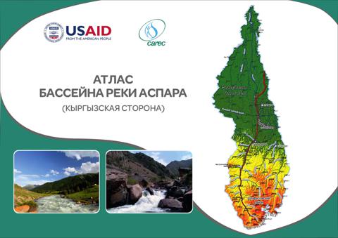 GIS & Mapping
2020
Maps for the Aspara and Isfara basins; atlases for Kurkuroo, Aspara, Padysha-Ata, Isfara and Isfana-Aksuu.
Open2019
Land-use inventory with Collect Earth by the six IPCC land-use categories and a national digital land-use map.
Open2012–2018
Flight preparation, aerial photo and video capture, processing and digitising of orthophoto materials.
Open2012–2018
Digital cartographic data for the national land fund inventory of the Kyrgyz Republic.
OpenGIS Lab
A small browser GIS: switch base maps, load your own GeoJSON / KML / GPX, measure, search and export. Files you open stay in your browser — nothing is uploaded.
Services
GIS components of development projects: data needs, workflows, mapping for planning documents and quality control.
Interactive web maps and spatial web applications, plus testing and quality control of GIS apps.
Spatial analysis, data processing and preparation of GIS inputs for modelling specialists.
Topographic plans and terrain data prepared to project specifications.
Field positioning and control points tied to the required coordinate system.
UAV flight preparation, aerial photography, processing and orthophoto digitising.
Landsat / Sentinel analysis in Google Earth Engine, NDVI, image classification and land-use mapping.
Land management, land inventory and cadastral analysis based on spatial data.
Thematic maps, atlases, map standards and print-ready cartographic materials.
Geodatabase design, data conversion, regular updating and quality control.
Contact
Consulting assignments, project positions and geospatial services — write a short description and I will reply by email.